


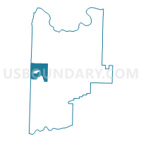
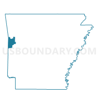
Voting District 9-3-B, Sebastian County, Arkansas
About
Outline

Summary
| Unique Area Identifier | 528181 |
| Name | Voting District 9-3-B |
| County | Sebastian County |
| State | Arkansas |
| Area (square miles) | 17.88 |
| Land Area (square miles) | 17.53 |
| Water Area (square miles) | 0.35 |
| % of Land Area | 98.05 |
| % of Water Area | 1.95 |
| Latitude of the Internal Point | 35.18565730 |
| Longtitude of the Internal Point | -94.39798260 |
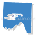
Maps

Graphs
Select a template below for downloading or customizing gragh for Voting District 9-3-B, Sebastian County, Arkansas


Neighbors
Neighoring Voting District (by Name) Neighboring Voting District on the Map
- Voting District 107, Le Flore County, OK
- Voting District 109, Le Flore County, OK
- Voting District 9-3-A, Sebastian County, AR
- Voting District 9-3-C, Sebastian County, AR
- Voting District 9-3-E, Sebastian County, AR
- Voting District 9-3-F, Sebastian County, AR
- Voting District 9-4-D, 9-4-E, 9-4-F, Sebastian County, AR
- Voting District 9-4-G, Sebastian County, AR
- Voting District 9-4-I, Sebastian County, AR
- Voting District 9-4-J, Sebastian County, AR
Top 10 Neighboring County Subdivision (by Population) Neighboring County Subdivision on the Map
- Center township, Sebastian County, AR (10,762)
- Marion township, Sebastian County, AR (4,689)
- Pocola CCD, Le Flore County, OK (4,398)
- Cameron CCD, Le Flore County, OK (3,806)
- Bass Little township, Sebastian County, AR (2,285)
- Cole township, Sebastian County, AR (1,908)
- Mississippi township, Sebastian County, AR (1,160)
- Jim Fork township, Sebastian County, AR (1,000)
- Prairie township, Sebastian County, AR (877)
Top 10 Neighboring Place (by Population) Neighboring Place on the Map
Top 10 Neighboring Unified School District (by Population) Neighboring Unified School District on the Map
- Greenwood School District, AR (19,838)
- Pocola Public Schools, OK (3,946)
- Hartford School District, AR (3,169)
- Hackett Public Schools, AR (2,923)
- Cameron Public Schools, OK (2,229)
Top 10 Neighboring State Legislative District Lower Chamber (by Population) Neighboring State Legislative District Lower Chamber on the Map
Top 10 Neighboring State Legislative District Upper Chamber (by Population) Neighboring State Legislative District Upper Chamber on the Map
Top 10 Neighboring 111th Congressional District (by Population) Neighboring 111th Congressional District on the Map
Top 10 Neighboring Census Tract (by Population) Neighboring Census Tract on the Map
- Census Tract 103.02, Sebastian County, AR (6,882)
- Census Tract 103.01, Sebastian County, AR (6,086)
- Census Tract 401.02, Le Flore County, OK (4,398)
- Census Tract 403.02, Le Flore County, OK (3,806)